Table of Contents
Climates
Transport Fever 2 has the ability to define different climate zones. They vary in the look and feel of the environment, as they have different plants, colors, terrain textures and lighting.
Configuration
A climate zone is defined in a .lua file in the res/config/climate/ folder. Usually they are called <climatename>.clima.lua. The file has the following setup:
function data()

return {
  id = "temperate",
  name = _("Temperate"),
  desc = _("Mixed forest vegetation"),
  vehicleSet = "europe",
  order = 1,
  mapColoring = {...},
  groundTextures = {...},
  skirt = {...},
  updateFn = function(params)
}
end
While id is a unique technical identifier, name and desc are strings which can be translated in a strings.lua file. The vehicleSet property is a reference to the vehicle set that should be preselected in the main menu dialogs. The climat zones are ordered in the dialogs according to their order values. The default climates use the order indices 1,2 and 3.
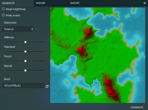
The mapColoring block defines the colors that are used for the map preview in terrain generator dialogs. It has several properties:
levelsis a list of level definitions. Each level stands for a color at a certain height and consists of two values:coloris a color definition with three values between 0 and 1. It is possible to use themaputil.MakeColor(r,g,b)function in themaputil.luascript to convert from 255 based colors.heightis the heightlevel at which this color should be used. Intermediate height levels are interpolated between colors.
waterColor0is the color definition for the shallow water in the shore area.waterColor1is the color definition for the deep water area.ambientColoris the color definition for the overall color grading of the preview map.sunColoris the color definition for the sun exposure.

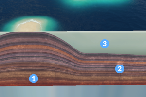
The groundTextures block is used to assign special ground textures for several purposes. The references are all relative to res/config/ground_texture/:
waterGroundis the texture that is used below water, e.g. in lakes and rivers.waterShoreis the border texture that is used along the shoreline.farmlandis the texture used for for farmland areas.farmlandBorderis the texture used for the border around the farmland areas.
The skirt block is used to define the textures used for the edges of the game world. It is common that functions of the texutil.lua from the res/scripts/ folder are used to provide the texture maps for the skirt block.
1 colorTex is the texture map that is used as base colors for the edge faces.
2 detailTex is the texture map that is used as overlay to get some randomzation of colors at the faces.
3 waterText is the texture map that is used as base color for the areas of edge faces that touch water.
The updateFn is used to generate the terrain textures all over the map.
UpdateFn
The updateFn is a function that is called after every change of terrain to recalculate the default terrain texture distribution over the map. It gets several parameters in a data struct:
layers generated by updateFn
| key | type | description |
|---|---|---|
bounds.max.x | integer | The maximum value of map bounds in x direction |
bounds.max.y | integer | The maximum value of map bounds in y direction |
bounds.min.x | integer | The minimum value of map bounds in x direction |
bounds.min.y | integer | The minimum value of map bounds in y direction |
mapSizeX | integer | The actual map size in x direction |
mapSizeY | integer | The actual map size in y direction |
waterLevel | integer | The height of water level |
The expected return data struct contains a mixingLayer property that contains several terrain texture layers:
{
  -- intermediate results

  mixingLayer = {
    backgroundMaterial = "grass_light_green.lua",
    layers = {
      -- Standard grass
      {
        map = layer2Map,
        dither = true,
        material = "grass_green.lua",
      },
      ...
      -- Slope rocks
      ...
      -- Beach materials
      ...
      -- River materials
      ...
    }
  }
}
no dithering and dithering
The material references are all relative to res/config/terrain_material/. The one referenced at backgroundMaterial is painted as a primer all over the map. The layers below are painted over it, layer by layer in the order they have in the list. Each layer has three properties:
mapis a data map that was computated before. It serves as a mask for the terrain material.ditherenables the dithering effect at the edges of the texture.materialis the reference to a terrain material.
The map layers usually are computed by using the layersutil.lua that can be found in res/scripts/terrain/ folder. It provides a lot of operations which can be used to generate the mask maps.
UI Icons
The ui icons for climates are used in some main menu dialogs. They are located in the res/textures/ui/climate/ folder and are named <climatename>@2x.tga. Their resolution should be 300×200 pixels.